
 Translate
Flooding in the Green-Duwamish River Watershed
About flooding in the Green-Duwamish River watershed
The Green-Duwamish River watershed is the area of land that drains snowmelt and rainwater into the Green and Duwamish rivers. The Green River begins in the Cascades and flows northwest 93 miles to its outlet in Elliott Bay via the Duwamish River. The Soos, Newaukum, and Mill creeks as well as the Black River all flow into the Green River.
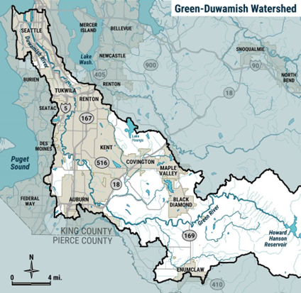
The Green-Duwamish River watershed is entirely within King County. Auburn, Kent, Renton, Tukwila, Seattle, and unincorporated areas of King County are within the watershed. The land includes protected forests, agricultural lands, residential communities, and commercial areas. Public facilities and important roads, highways, and rail lines are also located in the watershed. Many people commute to and through the Green River Valley. The watershed is usually divided into four sub-areas:
- Upper Green River, which extends westward from Stampede Pass in the Cascades and includes the Howard A. Hanson Dam and reservoir. The Dam, which has been in operation since 1962, helps reduce the risk of flooding in the watershed. There is very limited access to this forested area of the watershed.
- Middle Green River, which begins downstream of the Howard A. Hanson Dam and runs to Auburn. The river meanders in this area. Much of this land is used for farming, with some residential development. There is important habitat in the Middle Green for fish and wildlife.
- Lower Green River, which runs through the cities of Auburn, Kent, Tukwila, and Renton to the Duwamish River near I-405. In this area, the river is more confined by development. The land around the river is home to many people and businesses, and even factories. There are also important agricultural areas.
- Duwamish River, which flows into Elliot Bay. This is another area with homes and businesses. There are also marinas and facilities to support commerce and transportation around the mouth of the river.
Flood risks in the watershed
- Flooding is common and widespread through agricultural and undeveloped areas in the Middle and Lower Green River.
- Areas in Auburn and the Middle Green are at risk of channel migration. This is a natural process where rivers can change paths over time.
- The Lower Green-Duwamish River is at risk of flooding in residential, commercial, and industrial areas, particularly in the cities of Auburn, Kent, Renton, and Tukwila.
- Tidal flooding from rising and lowering sea levels is a concern along the Duwamish River. Scientists expect the potential for this hazard to increase as sea levels rise.
King County, as service provider to the King County Flood Control District, monitors and maintains 28 miles of levees and revetments throughout the watershed. A levee is a raised structure built along a riverbank to contain, control, or divert the flow of water and protect land along the river from temporary flooding. A revetment is a structure built along a riverbank to prevent erosion. King County coordinates with the U.S. Army Corps of Engineers that owns and operates Howard A. Hanson Dam. Although it is not possible to prevent all flooding, the Dam and the levee system help reduce flood risks to neighbors and the community.
The importance of healthy floodplains
Connected floodplains provide space to store flood water and habitat for fish and wildlife. The Green-Duwamish River watershed provides important habitat for Chinook salmon and steelhead trout listed under the Endangered Species Act. Changing the natural or built environment can affect fish habitat, including water quality and temperature. We consider potential impacts to these species when designing flood risk reduction projects.
Resources
King County flood alerts
Sign up for Green River flood alerts
Check your river gage data
A river gage station is a location where hydrologists, or people who study the flow of water, gather information such as the height and depth of a river and the speed of the water flow.
Additional resources
Learn how to prepare for a flood
Free sandbag materials are available in Renton and Seattle
Want to learn more about the future of your watershed?
Green-Duwamish Watershed Strategy
Learn about the Green River System-Wide Improvement Framework (SWIF). This is a strategy to maintain and improve the system of levees in highly developed areas of the watershed. A levee is a raised structure built along the riverbank to help contain flood water within the river to reduce the risk of flooding. The SWIF also includes activities to help communities understand flood risks.
The King County Flood Control District is considering developing a Lower Green River Corridor Flood Hazard Management Plan that would guide future investments to reduce flood risks over the next 30-50 years. Learn more about the project at lowergreensepa.org.
Projects to improve and setback levees further from the river, where possible, are also underway. Discover some of the current flood risk reduction projects below.
Projects and studies
Current projects and studies
- Black River Pump Station Improvements (located in the City of Renton)
- Fort Dent Levee Repair project (located in the City of Tukwila)
- Gunter Levee Improvement project (located in the City of Tukwila
- Kent Airport Levee Repair project (located in the City of Kent)
- O'Connell Revetment Repair project (located in the City of Kent)
- The revetment reduces flood risk for Frager Road South, five private homes, and active agricultural land. Inspections after flooding in 2020 found erosion that threatens the structure of the revetment, a guardrail, and road infrastructure along Frager Rd South. King County plans to repair the damage in 2025.
- PL 84-99 Repairs – Desimone (located in the City of Tukwila), McCoy (located in the City of Kent), Gaco Western
- All three projects will repair damaged levees in partnership with the U.S. Army Corps of Engineers under the P.L. 84-99 Levee Rehabilitation and Inspection Program.
Key reports, studies, and surveys
Green River System-Wide Improvement Framework
Green River Channel Migration Zone Study
January 2013 Middle Green Levee Setback Feasibility Study
Climate Impacts Group study of the effect of climate change on flooding in the Green River
Recently completed projects
- Lower Russell Levee Setback 2023 (located in the City of Kent)
- Lones levee – Cakwab Levee Setback and Floodplain Restoration Project 2021 (Middle Green River near Auburn)
- Tukwila Revetment Repair 2021 (located in the City of Tukwila)
- Flooding in 2020 damaged a revetment along the Green River Trail. The site was repaired to protect the safety of trail users, improve user experience and extend the life of the trail.
- Galli’s Dykstra Feasibility and Repair Project 2021 (located in the City of Auburn)
- King County identified three low spots along a major levee system. This project made improvements to raise the height of the levee prism to provide uniform flood risk reduction to residential and commercial areas nearby.
- Teufel PL 84-99 Mitigation 2020
- This project fulfilled mitigation requirements for tree removal work on federal levees. The project placed logs and planted trees to enhance salmon habitat.